Click on the appropriate link to access the information you wish to view:


Panama History - A Brief Overview

Panama's history has been shaped by its strategic location between the Pacific Ocean and the Caribbean. The native Cuevas and Cocole tribes quickly disappeared after the Spanish arrived with their weapons and diseases in the early 16th century. Panama City, on the Pacific coast, thrived as Spain conquered and plundered Peru. Caravans loaded with gold traveled overland across the narrow isthmus from Panama City to be loaded on galleons bound for Spain. However, this wealth attracted pirates and, in the early 1700s, Panama's Caribbean shore was dotted with so many pirate strongholds that shippers chose instead to sail around Cape Horn to Peru. Panama's importance rapidly declined, and Spain did not contest its inclusion as a province of Colombia when that country won its independence from Spain in 1821.

Recent History of Panama

In 1968, the commander of the Panamanian National Guard, Omar Torrijos Herrera, seized control of the government. Although he ruled as a populist dictator, Torrijos Herrera is revered as a hero of Panama because he negotiated the treaty with the United States returning the canal and the Canal Zone back to Panama on January 1, 2000.

After Torrijos Herrera's death in 1983, General Manuel Noriega became head of the Panama Defense Forces. When Noriega's party lost the 1989 elections, Noriega's cronies physically attacked the winning candidate on national television, and Noriega remained in power with the income provided by drug trafficking. In December 1989, Noriega appointed himself dictator and formally declared war against the United States. The next day, a U.S. soldier was killed by Panamanian soldiers and the most powerful country in the world sent 26,000 troops into the streets of Panama City and Col ón. Thousands died in the fighting, and Noriega claimed asylum in the Vatican Embassy. The Vatican staff finally released Noriega into U.S. custody, partly to stop the assault of loud rock music that U.S. loudspeakers directed at the embassy compound both day and night. Noriega was arrested, tried, and convicted on money laundering charges and sent to prison for a 40-year sentence.

Still suffering form his beating by Noriega's cronies, Guillermo Endarra, the winner of the 1989 election, finally took office, but corruption and social unrest were hallmarks of his regime. Ernesto Perez Balladares (El Toro) won the 1994 election with largely fulfilled promises to fight corruption, improve Panama's economy, and implement nationwide health services. Running with the campaign slogan, "The Canal Is Ours" Mireya Moscoso, the widow of a popular former president and head of the conservative Arnulfista Party, won the presidency in 1999 and celebrated with her people when the year 2000 dawned with the canal finally belonging to Panama.


Return to the top of the page


Panama Map & Geography


Panama Geography - facts and figures

Strategic location on eastern end of isthmus forming land bridge connecting North and South America; controls Panama Canal that links North Atlantic Ocean via Caribbean Sea with North Pacific Ocean.

Geography of Panama Stats

Land Mass Total
30,193 sq mi (78,200 sq km)

Land
29,339 sq mi (75,990 sq km)

Water
853 sq mi (2,210 sq km)

Land Boundaries
Total: 344 mi (555 km)

Border countries: Colombia 139 mi (225 km), Costa Rica 205 mi (330 km)

Coastline
1,547 mi (2,490 km)

Maritime claim
Contiguous zone: 24 nm
Exclusive economic zone: 200 nm
Territorial sea: 12 nm

Climate/Weather
Tropical maritime; hot, humid, cloudy; prolonged rainy season (May to January), short dry season (January to May).

Terrain
Interior mostly steep, rugged mountains and dissected, upland plains; coastal areas largely plains and rolling hills.

Elevation extremes
Lowest: Pacific Ocean 0 ft (0 m)
Highest: Volcan de Chiriqu í 11,400 ft (3,475 m)

Natural Resources
Copper, mahogany forests, shrimp, hydropower.

Land use (1998):
Arable land 7%
Permanent crops 2%
Other 91%

Natural hazards
Occasional severe storms and forest fires in the Darien area.

Panama Environment - current issues

Water pollution from agricultural runoff threatens fishery resources; deforestation of tropical rain forest; land degradation and soil erosion threatens siltation of Panama Canal; air pollution in urban areas; mining threatens natural resources.


Return to the top of the page


Panama Canal Overview


Overview:

The history of the Panama Canal is fascinating. In the 1880s, Colombia made a treaty with France for the construction of a canal across Panama's narrow isthmus, but yellow fever claimed the lives of more than 22,000 workers over a five-year period, and construction was halted. Over Colombia's objections, one of the French investors negotiated a deal to have the United States construct a canal just at the time that Panama's independence movement needed tactical and financial assistance. When Panama declared its independence from Colombia in November 1903, U.S. troops were already present to "protect" the new government. In return for constructing a canal, the new Panamanian government granted U.S. control over rights on either side of the canal "in perpetuity," and U.S. president Theodore Roosevelt's "Panama Doctrine" began with the eradication of mosquitoes, which carried malaria and yellow fever. The Panama Canal was completed in 1914 and has remained an important shipping route ever since. In 1921, the United States paid Colombia US$25 million in exchange for revoking all claims on Panama, and in 1936, the United States finally gave up the legal right to use its troops outside the borders of the Canal Zone. With the onset of World War II, the canal became one of America's most valuable strategic assets and was heavily protected by fleets of U.S. warships.

This is the first set of locks situated on the Pacific entrance of the Panama Canal. The locomotives maneuver the ships through the locks prior to being raised or lowered 27 feet per chamber. Twenty six million gallons of water is transferred in only 7 minutes and all done by gravity. Your bath tub doesn't drain that fast.

There are three sets of locks in the Panama Canal. On the Pacific entrance are Miraflores, with two chambers, and Pedro Miquel with one chamber. On the Atlantic is one set of locks with 3 chambers, the Gatun Locks. Ships are raised a total of 87 feet above sea level into Gatun Lake and then lowered at the end of their transit into the other ocean. A common misconception is that one ocean is higher that the other, but they are both at sea level.

Panama receives as much as 200 inches of rain per year. This was a determining factor in placing the canal there since 52 million gallons of fresh water is lost to the ocean on each transit.
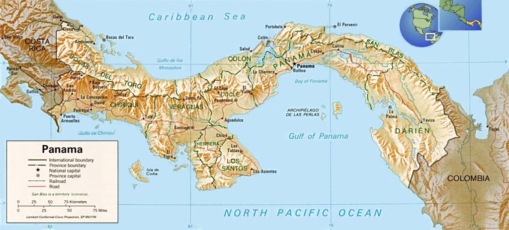
Panama is situated just a few degrees from the equator. The climate is quite warm and humid with the humidity always high, around 80 percent.

Building the Canal:

The Panama Canal extends across the Isthmus of Panama from Colon on the Atlantic Ocean (Caribbean Sea) side, to Balboa and the Pacific Ocean.

It was built in two stages; 1881-1888 by the French, followed by the Americans, with their efforts completed in 1914. In 1883 it was realized that the tide level at the Pacific side was almost 19 feet higher than the Atlantic side. Engineers concluded the difference in levels would be a danger to navigation. It was proposed that a tidal lock be constructed near Panama City to preserve the level from there to Colon.

Eventually, due to some new thinking, and in an effort to do it right the first time, it was decided that the original plan should be modified and a widely accepted lock system should be used.   As an example, when a ship traveling from the Atlantic side reaches the Gatun Locks, a series of three locks raise that ship about 85 ft. to Gatun Lake. Then it's a 40 mile trip to the locks at Pedro Miguel, locks that lower the ship 30 feet. At the Miraflores locks the ship is lowered an additional 52 feet to Pacific Ocean sea level.

During the invasion of Panama by the United States in 1989, in their successful effort to remove the de facto ruler General Manuel Noriega from office, the canal was closed for the first time in its history. Managed for decades by the U. S. A., the canal was returned to Panama on December 31, 1999.


Return to the top of the page


Panama Soberania National Park


Overview:

Soberania National Park is located 20 minutes from Panama City. It is over 55 000 acres in size.  This park is comprised of tropical humid forest and is located on the banks of the Panama Canal. Here you will see more than 1300 plants and over 100 animals.  This area is world renown for it's abundance and diversity of birds.

Soberania National Park is situated in the province of Panama and Colon. There are several famous historical sites and important biological sites in the Soberania Park. For example : Pipeline road (Camino del Oleoducto) held the world record in 1985 for the number of avian species identified in a 24 hour period. If history is your interest Camino de Cruces was used by the Spanish conquistadors to transport gold and other cargo from Peru to Spain.

Soberania Park is located so close to civilization that it is amazing that so much wildlife can be viewed. It is said to be the most accessable rainforest park in the world. A walk in the morning down one of the well marked trails can allow you views of sloths, coatimundis, toucans, and kinkajous - and still be in an air conditioned restaurant for lunch!

There are several places in the forest to stay in and around the Soberania National Park - the Canopy Tower and Gamboa Rainforest Resort are 2 Eco tourism resorts of high repute.

Hiking and Camping

Hiking and camping permits are available at the ANAM office at the edge of the park. The office is open 8 a.m.–4 p.m. weekdays, staff live on the property so you can usually get into the park. The fee for park entrance is $3. Camping is $5 / night. Entrance fee is $3, which gives visitors access to all the trails for the day. The camping fee is another $5. The camping is not structured so don't expect a camp site with a BBQ!


Return to the top of the page


Created on: 2011.01.10
Return to the Panama Home  Page
Updated on: 2020.09.21